
National Land Agency advancing blue economy through Hydrography Programme
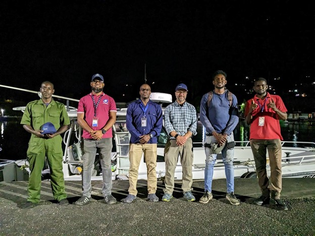
From left: JDF Coast Guard, LS Cox, Z; Senior Hydrographic Surveyor, National Land Agency, Diego Billings, Assistant Hydrographic Surveyor, National Land Agency Brian Scott, President, TCarta Marine LLC, Kyle Goodrich, Assistant Hydrographic Surveyor, National Land Agency, Matthew-Dane Henry; Field Assistant, National Land Agency, Orean Hinds after a technical exchange activity where the hydrographers trained Goodrich on how to use a multi beam echo sounder to determine the water depth of the East and West Harbours, Port Antonio, Portland.
~~~~~~~
The National Land Agency (NLA) is reaffirming its commitment to supporting the development of the blue economy by implementing a robust and effective hydrographic survey programme.
This is against the backdrop of World Hydrography Day, which is being commemorated globally today (June 21) under the theme, ‘Hydrography – Underpinning the digital twin of the ocean’.
According to the International Convention for the Safety of Life at Sea (SOLAS), 1974, Jamaica, through the National Land Agency, is responsible for conducting hydrographic surveys of its coastal waters. The Agency is acknowledged as the national hydrographic office and, through its Hydrography Unit, charts the underwater landscape of Jamaica's territorial waters.
Senior Hydrographer at the National Land Agency, Diego Billings, explained that the Agency honours its fulfilment to its stakeholders through the collection, maintenance, and distribution of precise and accurate data obtained from regular surveys of Jamaica's ports and harbours.
“Since the start of the year, the hydrographers of the Agency have conducted routine surveys of Rosey Hole, Port Royal, and the West and East Harbours of Port Antonio this year. The information collected from these surveys is crucial for ensuring smooth and safe navigation for ships and other marine activities,” he said.
Some of these activities include maritime boundary delimitation, national marine spatial data infrastructures, marine defence and security, coastal zone management, and recreational boating, among others.
He also mentioned that ‘improved understanding of the sea floor through hydrography can be used to harness the full potential of the blue economy by seizing opportunities to boost economic growth, improve livelihoods and intensify trade activities, all while preserving the seas ecosystem”.
By the end of 2023, the Agency plans to conduct four additional hydrographic surveys of the Montego Bay, Negril, Black River, and Ocho Rios Harbours.
Billings further mentioned that the quality of the hydrographic survey results has been enhanced with the help of technological advancements.
“We recently employed the satellite derived bathymetry (SDB) method in our hydrographic surveys. This approach enables us to produce bathymetric maps of extensive regions, which allows for more effective and efficient use of time and resources,” the Senior Hydrographer said.
This was first accomplished through a collaborative case study with TCarta Caribe in 2020 where a hydrographic survey was completed of the Bowden Harbour in St Thomas using SDB.
He further expounded that “drones have also been used to map the shorelines of the seas which has resulted in significant reduction in the overall time it takes to complete surveys.”
Jamaica holds the position of council member within the International Hydrographic Organization (IHO) and with such responsibility there is increased motivation to expand the country’s imprint in the arena of ocean mapping. Plans are, therefore, underway for Jamaica to participate in the Nippon-Foundation-GEBCO Seabed 2030 Project. This initiative aligns with the United Nation’s Sustainable Development Goal 14 which is to conserve and sustainably use the ocean, seas, and marine resources for sustainable development.
As part of this Project, hydrographers from the NLA will be tasked with mapping Jamaica’s Exclusive Economic Zone (EEZ). This team consists of two Category-A and one Category-B hydrographic professionals who have received international training and are certified by the International Federation of Surveyors (FIG), International Hydrographic Organization (IHO), and International Cartographic Association (ICA).
"It will be a challenging yet rewarding endeavour. By 2030, the hydrographic data collected from Jamaica's EEZ will be combined with other seabed mapping data to create a comprehensive digital map of the world's ocean floor. We are enthusiastic about the potential of this global endeavour and its impact on the development of Jamaica's blue economy," he expressed.
June 21st marks the annual observance of World Hydrography Day, which was initially proposed to the United Nations General Assembly in 2005 by the International Hydrographic Organisation. The first official commemoration of this day was held in 2006.
Workshops
Land Registration and Conveyancing Workshop starts May 13, 2025
Social Links
Live Chat Count Down
Contacts
For general information about our services, please contact us at:
- asknla@nla.gov.jm
- +876.750.5263
- +876.946.5263
- +876.418.5089
- 8 Ardenne Road Kingston 10